Menu di navigazione

You are in: Home page > Magazine Archive > Innovative urban models

Carlo Manzo
Innovative urban models
Urban projects for the Sarno plain

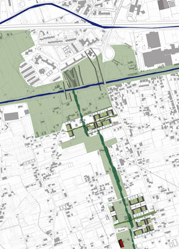
Sarno plain settlements.

Abstract
Looking for a strategy avoiding sprawl and soil cementing in the Sarno plain, we compact new buildings in a discontinuous system of multifunction residential clusters with greenhouse, following the criterion low rise high density.
The aim is a green extended city, built up by urban parts with residential and productive structures and by utilities separated by rural areas and parks. The discontinuity of new parts alternating with agricultural plots allows that green and unbuilt areas avoid the building saturation of span among the detached cities.
The Sarno river should become an element to order the next plans, increasing the multifold relationships among rural and modern settlements.
The Sarno plain, a well-known area for its specialized crops and manufacturing industries, today has a twofold nature which explains the uneven buildings concentrations. On the one hand, the area has been affected by strong pressures from the urban area of Naples which have led into high densities of buildings on the coast. On the other hand, the agrarian character of the Sarno river valley accounts for the low building density moving upriver further inland. Besides the main building densifications on the coast and on the piedmont ribbons, the Sarno plain today looks as a set of urban settlements connected by thin built strips along the roads, alternating with rows of greenhouses, small factories and warehouses, and crossed by a dense network of canals.This low architectural qualitys settlement system contains a large stretch of rural countryside which could be saved and reintegrated within a hypothetical extentended city.
If the Rossi theory of the city by parts is transferred to a local scale, the Sarno plain can be viewed like the basis of a multi-polar settlement, extended into the countryside: the existing urban settlements resemble multifunctional districts, the cultivated areas correspond to parks and gardens, and the system of public buildings coincides with the most important historical building and the infrastructures.
A long time the river has played an important part in defining the constituent features of the countryside, now it seems an extraneous feature to the countryside layout, and it can even be considered one of the multipliers of the ecological disaster of this area. With a few exceptions, there have been no significant examples of urban construction on the river or on its canals. The Sarno can be considered a privileged vantage point from which to tackle the settlement problems of the area.
This is why this study has regarded it as an incubator of new relations and links between river sites and cities. Considering the environmental reclamation programmes and activities related to horticulture and floriculture, the upgrading initiatives on the river (such as restoring its old navigability) could play a leading role in the reorganisation of the area and the development of urban, rural and manufacturing settlements.
Our research has focused on several criteria for the territory transformation.
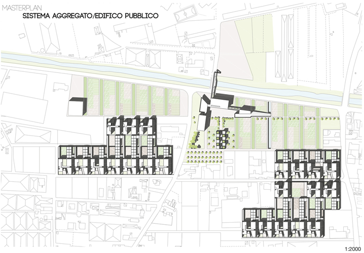
1. Adopting a design strategy to avoid sprawl and scattered buildings, we use a discontinuous system of accumulative forms of interventions, with mixed functions, based on the criterion of low rise high density. The basic idea is to build a green city made up of well-defined elementary parts of residences and productive structures, and of recognisable primary and infrastructural features, separated by cultivated green areas and parks. The parts consist of residential units integrated with greenhouses and workshops, or small industrial complexes, situated within the rural landscape, to enhance the importance of integration between urban and rural features.
2. The design solutions, following the criteria of discontinuity and alternation between the residential-manufacturing parts and the agricultural zones and parks, helps to ensure the presence of unbuilt areas, as buffer zones that prevent urban sprawl and the linking of urban centers.
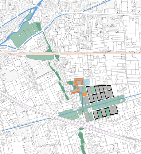
3. The Sarno river-canal network is considered the backbone of the local framework which needs to be redeveloped and reinforced both from the functional and landscape perspective. It has the role of a regulating feature of the urbanized countryside transformations, restoring landscape continuity and linking functions between sites associated with rural traditions and modern settlements.
4. The proposed interventions are arranged according two directions. Those along the longitudinal one are situated along the Sarno river which is redeveloped and reinforced with a series of facilities and public places. The upgrading of the river-bed, the lateral canals zones provides new margins and layouts, as useful reference points for the transformations of built-up areas and urban centers nearest to the river. The new facilities on the river are designed to be incubators of collective activities in public green areas. The aim is to rebuild relations and hierarchies between existing urban areas preserving and enhancing agricultural areas. The new areas are designed by offer a way to cross slowly the plain, along the course of the river. A series of recognisable zones, collective places for existing urban settlements, have been identified along the Sarno where a series of activities are linked to pre-existing features (archaeology, nature, agriculture and tourism).
5. The transversal plot has been used where the river and other infrastructures, such as motorways and railways, have built a stiff demarcation of the area in an east-west direction, and the design will re-establish relations between the two river-sides. This will create new ways of crossing two sides to ensure better functional and visual relations. The ways crossing the water course therefore provide links among river, urban centers and new residential-productive units, reinforcing the flight routes running away from the Vesuvius eruption risks. Small compact clusters of residential and productive units, together with new facilities, will improve the transversal zones. Supporting this settlement pattern, planning guidelines have been followed town planning regulations (starting from PUC rules), to legalize unlawful accommodations built up in the last period, and to avoid building increases in the red zone, for volcanic risk.
The strategy of transversal initiatives also guides the design of innovative infrastructures, such as the plan for a horizontal cableway between two Pompei river-sides which would overpass over the Sarno to link southern areas with the archaeological area and the Shrine, most important resources of Vesuvius territory.
Productive residences and compact horizontal units are designed to create a green city building an anti-spawl strategy on the densification of residential settlements. These multi-function units, integrated with agricultural activities, will become the main features of a controlled redesign of the landscape. In architectural terms, they are well-defined parts, small fenced-off sectors or clusters, according to the relationships of continuity, discontinuity or alternation to set up with natural features and the characteristics of the different contexts.
Besides the new residential units, provided with services and facilities, intend to discourage fragmentary residential accommodation. On the one hand, the integrated low rise-high density clusters are inspired by the idea of a small community equipped with infrastructures and collective services, while on the other hand, they safeguard the autonomy of the individual units, meeting single family or parental house expectations. Designed as coordinated local plans, these initiatives are intended to encourage aggregation and cooperation, promoting rationalisation for the production, distribution and sale of horticultural and floricultural produce. Each residential unit consists of fenced or opened housing plots suitable for the rural-urban nature of these areas, considering also the danger of overflow. From the architectural perspective, this involves a reinterpretation of the suburban detached house or the courtyard house, closely linked to the design of free and cultivated areas. In functional terms, the design proposes an extended use of the productive house (up to 5 flats) with a close link between domestic spaces and work spaces (greenhouse and workshop).
In order to allow a gradual reduction of land occupation, the study of the extended city investigated equalisation mechanisms for local regeneration in the southern area where industrial buildings of low architectural quality exist side by side with floricultural greenhouse cultivation.
Bibliography
Agnoletto, M., Guerzoni, M. (a cura di) (2012). La campagna necessaria. Unagenda di intervento dopo lesplosione urbana. Macerata: Quodlibet.
Bottoni, F. Villani, A., De Divitiis, M. R. (2006). Economia ed industrie nellagro nocerino-sarnese. La memoria delle immagini. Cava dei Tirreni.
Di Gennaro, A. Innamorato, F. (a cura di) (2008). Una campagna per il futuro. La strategia per lo spazio rurale nel Piano territoriale della Campania. Napoli: CLEAN.
Manzo, C.A. (a cura di) (2012) Recinti metropolitani- Costruire la pianura campana. Roma: Kappa.
Chouquer, G. et al., (1987). Structures agrarie en Italia centro-meridionale, Ecole Francaise de Rome: Roma.
Fresa, A. Fresa, M. (1974). Nuceria alfaterna in Campania. Napoli: F. Fiorentino.
Pesce, A. Milone, A. (2006). Una storia scritta sullacqua. Napoli: Massa Edizioni.
Miano, P. (2002). Dalla casa unifamiliare alla casa urbana di Pompei, Napoli: CUEN.
Autorità di Bacino (www.autoritabacinosarno.it) - Parco naturale del Fiume Sarno, Bollettino Regione Campania 27-5-2004.
Musi, P. (2003). Metonimie. La terra del Sarno, CITTA: Patto dellAgro.
(2009). Provincia di Napoli, La prevenzione del rischio nellarea vesuviana, Napoli.
(2008). Quaderni AdB., Collana di studi, Documentazione e ricerca Autorità Bacino del Sarno, 2.
Carlo Manzo is Full Professor of Architectural and Urban Composition, he has been teaching at the Faculty of Architecture of the Second University of Naples since 2000. Since 2009, he has been Head of the Department of Design Culture.


Sarno plain eastern view.


