Menu di navigazione

You are in: Home page > Magazine Archive > The scale of the "smart city"

Rossella Ferorelli
The scale of the "smart city"
Living the public space of the network society
")
Perceptual studies about crossing experience of urban highways (from K. Lynch)
Abstract
Beyond the purely technocratic dimension of the first generation of projects about of smart cities, and intending instead the research field as complex and crossdisciplinary, the job is a research, historically based, about an interpretation of the nature and role of public space in this realm, which shows drastically revamped by technological innovations, even in its cognitive origins. Examining seminal and critical experiences, it concludes that the public space of the intelligent city is the site of the collision of the social, cognitive and perceptual scales, and opens to further reflections.
Article Text
The origin and reputation of the concept of smart city are due to what can now be considered a first generation of ideas, born about a more integrated management of certain urban phenomena thanks to some technological innovations arose in the late '90s, particularly aimed at the networking of information flows related to production and consumption of energy, mobility and environmental monitoring [1].
At the same time, however, the entire industrial sector born of those first approaches could not but gather widespread skepticism, due to its obvious tendency to shape as a field of investment on the part of the largest technology corporates - especially information technology - and to generate, accordingly, at least certain horizons of opacity about the possible short circuits between economic interests and actual social advantages brought by those research processes [2].
From the second half of the '00s, however, the now matured awareness of the cultural depth of the effects of these and other technological innovations, meanwhile spread globally, has allowed the horizon of interest in the matter widening significantly [3], particularly towards the relationship between urbanity and consolidation of social networks[1].
Here, therefore, we want to dwell on the observation of those socio-spatial effect, direct offspring of the information economy, whose importance for the development of urban studies we believe the more radical as generally neglected by the literature on smart cities, although bwing, in our opinion, the most profound, rooted into the origin of the sense of citizenship even in the cognitive spheres of society [4].
In this sense, as an alternative to focusing on smart cities designed as such from above, we choose to analyze what "spontaneous" effects produced indirectly by those same technological revolution on the social practices of use - and ultimately on the design - of new generation urban spaces.
Therefore, since the cognitive, philosophical, technological and social transformations ongoing are undermining the basic foundations upon which the classical criteria of "public" and "private" are rooted, and which the construction of the urban built has to date been based upon, we choose the contemporary public space as a field of investigation, for it being a domain whose identity is under the most critical developments and puts radical questions.
What public space for the smart city?
By "public space" we mean here not so much - or not only - to a summation of urban spaces more or less openly dedicated physical aggregation and social interaction, neither among those classically encoded (such as squares, parks, boulevards, etc.) nor among less typologically distinguishable ones. We are interested in a broader and symbolic concept of public space, understood as the whole field in which the relationship of form and urban life are played, as the form and content of the self-representation of the city, and as the arena in which analytical definitions of the character of urbanity in a determined age are created. For this purpose, it seems especially appropriate to inherit the method by Françoise Choay, who very effectively uses four images for four long phases of European urban development, in the description of which the salient features of each fall in line and an interpretation of the identity of the space - especially understood as public - that belongs to each of them emerges with sharp clarity [5]. Thus, there is a succession of the medieval contact space, characterized by an inseparable meld of domestic, productive and public space, immersed in a magical-mystical cultural macrocosm; the classic "theatrical space", dominated by the secular-geometric look; the "circulation space" of the disunited modern metropolis, ruled out of the car and the capital; the contemporary "connection space", working at the global scale.
Recently[2], the historian makes no secret that she had underestimated the relationship between the purely spatial criteria she used to divide the city's history and cultural revolutions that cause the transition from one phase to another. In this case, the dominant epistemic revolution in the Renaissance evolves the medieval space into classic; the Industrial Revolution leads the latter to the modern; and what she calls the "electro-telematic revolution, with technical dominance", that we now know more commonly as "information revolution", is the prelude to a city that revolves around the space of connection. For age reasons, Choay can only give a hint of this description, which can only be accomplished by those following its evolution in the making.
How do we live, then, the space of connection, backbone of the smart city?
Since the mid 60s, Kevin Lynchs perceptive approach comes to recognize the inseparable link between mediatization of the experience of the built space and extension of the self[3], observing that the feeling of inadequacy and discomfort one gets when experiencing a vast spacial scale, incomparable with the human body, disappears when going through the same space by car; and that this is a result of the amplification of speed and motion control, such as to overcome the physical scale relationship and to generate a feeling of mastery, only limited by the simultaneous sensory deprivation produced by the vehicle [6].
[Img01]
That of the speed, or the relation between space, the act of crossing, and time, will be a key concept of urban spatial theories for another twenty years [7], until the telematics will give way to information technology, to the spread of personal computers and to the advent of the internet, with the birth of cyberpunk culture and the exasperation of the division between physical and virtual-digital reality[4].
[Img02]
Only a few, sensitive observers will be able to understand, before the passage of the millennium, that technological progress would reconcile, and not detach, mankind from physical space through information, and that this will happen through an expansion of the perceptive faculties [8] in the same direction of the spatial control Lynch had predicted.
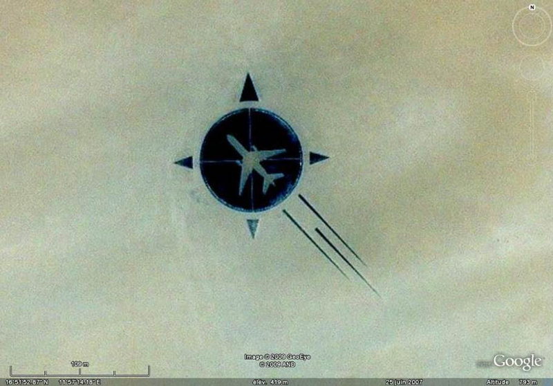
Its only in the second half of the '00s that the physical-digital break will be healed, thanks to the spread of civil satellite technologies, with the consequent possibility of free territorial data geolocation and the simultaneous mass propagation of portable tracking devices (locative media). The network increasingly becomes a location-aware environment, or its immaterial dimension is developed as a spatialized information field changing biunivocally the use practices of the physical space involved in the process [9]. An unprecedentedly vast audience develops a topographic culture based on the awareness of living constantly with the "cyberceptive" [8] possibility to look to themselves from above through the technologic eye of the satellite, at the same time engaged with to almost unlimited zoom and wide-angle.
The cultural effect of this innovation is beginning to be clear when a new geographical imaginary emerges and the first signs of this show in the new use (both civil and military) of drones, in some landart works and even in some controversial settlement interventions as the Palm Islands in the Persian Gulf.
[Img03]
[Img04]
Comparing Lynchs previously recalled observations and the cognitive potential of infinite optics expansion, it becomes obvious knowledge empowerment process for the citizens who, faced with the need to orient themselves in the urban public space, can have full access to incomparably increased sensory faculties and georeferenced bottom-up datasets, freely implementable.
Seminal experiences and criticism
As always in the vanguard, given the politically critical character of these increments of possibilities and, at the same time, given the speed and the transiency of the phenomena that affect them, in the early 2000s the field was explored primarily within artistic and critical-social activism experiences, which were numerous, varied and always intertwined with the design disciplines ì and with the sciences and the urban planning, at all the scales. Only recently have appeared some, seminal attempts to bring information-related digital technologies within the urban project, some of which seem to move towards results consistent with the historical and social interpretation this research is dedicated to.
Reasoning for major issues, you can see that there is a clear two-way approach between projects dedicated to spacialization of information (relating to intangible products such as software, app, locative media) and projects dedicated to the informatization of space (ie projects of urban public spaces in which information has a central role), but that this two-way nature is not yet completely resolved mature methodologies.
Spacialization of information
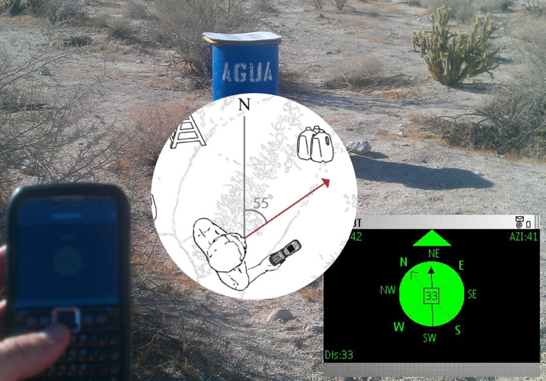
From the point of view of production spatialized information, the field of experience is, as mentioned, very broad, disciplinarily contaminated and often bearing strong social criticism. On a large scale, concepts such as geopolitics and citizenship collide increasingly with spacial elements such as borders and, interrogated by technology, generate controversial and transdisciplinary experiments around the subject of surveillance[5].
[Img05]
Even at the urban scale, among the most interesting themes of experimentation is certainly geofencing, namely the possibility of setting up intangible fences, georeferenced around physical locations. With the continuous advancement of satellite technology research and the resulting increase in accuracy of localization tools commonly available on the market, a variety of applications[6] enable interaction with urban areas that in fact call into question the concept of threshold with important consequences related to bio-political issues of access, freedom of movement and the risks linked to the opening of new channels of aggression by private interests in the uses of the urban public sphere [11].
[Img06]
Of Even different types are portable georeferencing-based applications which give back to the community information otherwise impossible to collect. One of them is Livehoods[7], which analyzes data from the principal social networks to trace the outlines of urban areas defined on the basis of homogeneous prevalent uses, generating readings of spontaneous city dynamics, that return results of a different type than the traditional up-down division, based on districts.
[Img07]
A further case of considerable interest, from this point of view, is made by the importance that the instrument of georeferenced mapping plays in the research practices in the area of adaptive reuse of abandoned buildings stock, that have proliferated in recent years, especially in our country [12]. In such experiences, the use of crowd-sourced mapping based on locative media is essential to the activation of public-private dynamic of reintegration for the decommissioned assets into the real estate market and in the collective imaginary, since the approach to the phenomena of abandonment occurred after the global crisis is particularly difficult due to their diffuse nature, uncontrollable by the traditional knowledge tools, which then generates important initial fact-finding deficits [12]. In this sense, particularly geo-social media (ie social media using georeferenced user-generated information), in addition to the initial localization of the objects, allow the bottom-up accumulation of multimedia information related to them, generating an initial reconnection between abandoned urban fabric and its social history (or creating a new one), which in most cases has proved the essential engine of subsequent interventions on the buildings and parts of landscape involved [9].
[Img08]
Informatization of space
From the point of view of the production of spacial design integrated with information, the state of the art is, as said, still extremely magmatic, because of the substantial mismatch between the evolution (and therefore of functional obsolescence) timing of technology and those of architecture. For this reason, in a phase of unstoppable race towards the maturation of the relationship between physical space and digital information as it is the one that characterizes the last decade of trials , the most interesting results are achieved within temporary structures, or inevitably end move designers involved in the research along these borders towards the choice of transiency.
Among the collective that have first (and longest) carried out studies and experiments in this direction, there is no doubt Hackitectura.net, active continuously in Seville from 2003 to 2011. Several of their early works, including "Cartuja Beta Rave" and "Fadaiat 2004"[8] represent attempts to make the size of the public space trans-scalar and trans-local, achieved through a spacial installation and satellite technologies available at that time[9] [13]. Conceptually similar to the theoretical project for a "Global Village Square" developed in 2000 by Derrick De Kerckhove [14], these works offer a vision of public space as a port for a realtime elsewhere, acting then as a mental device to make perceptible contemporary life belongs to all scales, from intimate to global.
From this generation's seminal work, in short, public space begins to be seen as a hub, a hotspot, or as a field in which a new right of its citizens is guaranteed, not just free access from outside into the space itself (in the classic concept of accessibility), but access from the space itself to the whole, global information available (property for which we propose the neologism "accessivity" [9]).
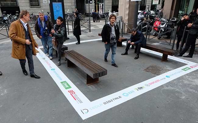
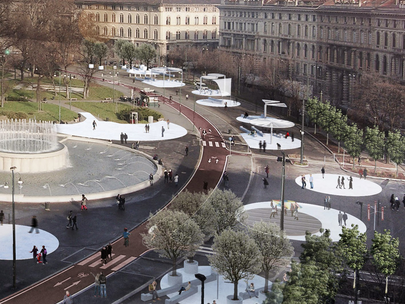
Today, this trend is materializing in a progressive refinement of the integrated project of the allocation of workstations equipped with electrical connections and wi-fi within the urban public spaces. The cases of the "digital islands" made in Milan for the Expo and, even more, the project by Guidarini and Salvadeo + Snark for the redevelopment of Piazza Castello, are emblematic of a growing awareness of the need to reconceptualize the "accessive" street furniture as core device for the design of contemporary public space.
[Img09]
[Img10]
[Img11]
A comparison between these realizations of physical informatized spaces (obviously less theoretically committed, but based on the new daily needs of metropolitan populations) with the experiences of spatialized information described above, allows to draw some observations.
As said, the production of "accessive" public spaces, or that provide access to information on a global scale, has meant, up to now, designing spaces whose character (although physical) is de-localizing, as they provide access for a permanent elsewhere globality.
On the contrary, even in their various forms, devices working on georeferenced software share the general aim of strengthening the sense of hereness, providing additional sensory and cognitive faculties regarding the space and time one it located in (typically, for better orientation or to obtain specific information on the characteristics of the place). This process of mutual augmentation of physical space and the net was first described by Lev Manovich in 2005 [15] and theoretical basis of a further technological branch known as Augmented Reality (AR)[10].
[Img12]
It seems therefore questionable whether this dichotomy of approaches is intended or not to lead to synthetic experiences, and whether is augmented reality (appropriately developed beyond the initial results it has landed, to date[11]) the missing link for this long-awaited reunion.
Conclusions
Despite the inherent fragility of any early applications of these innovations to the urban environment, we are not afraid to hazard to assert their synchronicity with the previously mentioned cultural change undergone by the concept of smart city is not casual. Today, in fact, we can say that the structure of smart cities is based on three orders of cultural devices:
- Location-aware information: georeferenced and portable internet;
- Information-aware locations: ie sensible environments, or spaces that produce information thanks to the implementation of sensor technologies;
- Social experience enhanced by the online realm, such as new fields of experimentation for social innovation.
For this reason, even waiting for the maturation of the theoretical and practical issues presented, it seems possible to state that the public life space of the smart city is a realm characterized by the collision and the coexistence of all possible spatial scales (from global to hyper-local), social dimensions (from the most intimate and private to the most public and official) and cognitive possibilities (thanks to the opportunity - perhaps illusory[12] [10] - to modulate constantly the access and awareness of the data on our surroundings).
The public space, today, is one in which, through information, we actively perceive the epochal change in which we are immersed.
Bibliography
[1] Harrison C., Eckman B., Hamilton R., Hartswick P., Kalagnanam J., Paraszczak J., Williams P. (2012) Foundations for smarter cities. IBM Journal of Research and Development, 54:1-16
[2] Söderström o., Paasche T., Klauser F. (2014) Smart cities as corporate storytelling, in City, vol. 18, n. 3, 307 320
[3] Batty M., Axhausen K., Giannotti F., Pozdnoukhov A., Bazzani A., Wachowicz M., Ouzounis G., Portugali Y. (2012) Smart Cities of the Future, in UCL Working Paper Series, n. 188, ISSN 1467-1298
[4] Moulier Boutang Y., (2010) Mutation in Contemporary Urban Space and the Cognitive Turning Point of Capitalism in Hauptmann D., Neidich W. (2010) Cognitive Architecture. From Biopolitics to Noopolitics. Architecture & Mind in the Age of Communication and Information, Nai, Rotterdam
[5] Choay F. (1970) Espacements. L'évolution de l'espace urbain en France. Milano. Skira.
[6] Lynch, K., et al. (1964) The view from the road, p 13. Cambridge. Mit Press.
[7] Virilio P. (1984) Lespace critique. Parigi. Bourgois Editeur.
[8] Ascott, R. (1995) The Architecture of Cyberception. In Toy, M. (Ed) Architects in Cyberspace. Pp. 3841. London. Academy Editions.
[9] Cariello, A., Ferorelli, R. (2013) Urban hacktivism e locative media. Strategie di riappropriazione dei paesaggi dellabbandono. In: Vitellio, I. (Ed.) Città Open Source. Spazio pubblico, Network, Innovazione Sociale. Urbanistica Dossier Online (6). INU Edizioni. ISBN 9788876031014
[10] de Souza e Silva A., Frith J. (2010) Locational Privacy in Public Spaces: Media Discourses on Location-Aware Mobile Technologies in Communication, Culture & Critique n 3, 2010 ISSN 1753-9129
[11] Cariello, A., Ferorelli, R. (2013) Spazi pubblici in rete laccesso come indicatore di rischi e opportunità del geosocial networking per la dimensione urbana. Atti della XVI Conferenza nazionale della Società Italiana degli Urbanisti, Urbanistica per una diversa crescita, Napoli, Maggio 9-10, 2013, in Planum. The Journal of Urbanism, no. 27, vol.2 (2013). ISSN 1723-0993
[12] Ferorelli, R. et al. (2014) Le reti sull'abbandono: mappature, progetti, pratiche per un riuso dal basso, in Filpa, A. Lenzi, S. Riutilizziamo l'Italia. Land transformation in Italia e nel mondo: fermare il consumo del suolo, salvare la natura e riqualificare la città, Report WWF 2014. ISBN 9788890662942
[13] Pérez de Lama, J. (2009) Public Space and Electronic Flows. Some Experiences by Hackitectura.net, in Inclusiva-net #2. Digital Networks and Physical Space. Texts of the 2nd Inclusiva-net Platform Meeting March 3 - 14, 2008. Directed by Juan Martín Prada Medialab-Prado in Madrid. Área de Las Artes. Madrid. ISSN 2171-8091
[14] de Kerckhove, D. (2000) Larchitettura dellintelligenza. Roma. Testo&Immagine.
[15] Manovich (2005) The Poetics of Augmented Space Vol. In: Visual communication. Vol. 5 (2), pp. 219-240. London. SAGE.
[1] Note, in this regard, the proliferation of funding recently provided by the European Union for the realization of social innovation projects under the headings of funding for smart cities. Among the most recent, in Italy, there is the call for projects issued by the Ministry of Education and entitled "Smart Cities and Communities and Social Innovation", whose results can be found at the following link: http://hubmiur.pubblica.istruzione.it/web/ Search / smart-cities-and-communities-and-social-innovation (last accessed: 29/01/15)
[2] Particularly, in the introduction to the Italian edition of Espacements issued in 2003 and edited by Ernesto D'Alfonso, for Skira.
[3] It should be emphasized the concomitance of these reflections with the publication of the most important studies of Marshall McLuhan, and in particular of Understanding Media (1964).
[4] Most celebrated through by the arts than by the sciences, and especially in underground cultural environments, the dichotomy real / virtual finds is in the novel Neuromancer by William Gibson one of its first and most effective portraits that have relegated the cyberspace to the dimension of pure spatial metaphor, until the following technologic generation.
[5] It is for example the case of the "Transborder Immigrant Tool", made by the b.a.n.g. lab collective, that uses the "cyberceptive" eye of the gps, applied to mobile phones even to not brand-new ones , to facilitate the interpretation of the desert territory forming the border between Mexico and South California to irregular migrants, in order to avoid the many deaths from thirst during the clandestine emigration.
[6] See the case of "MapAttack" playful app which makes a team game, based on the use of geofences, to be played in the urban context: https://geoloqi.com/blog/2011/09/building-a-real-time-location-based-urban-geofencing-game-with-socket-io-redis-node-js-and-sinatra-synchrony/ (Last accessed: May 3, 2015)
[7] http://livehoods.org/ (last accessed: May 3, 2015)
[8] The original wiki platform reporting the initiatives can be found at http://mcs.hackitectura.net/tiki-index.php (last accessed May 3, 2015), while the latest website, in blog format is: http: //hackitectura.net/blog/ (last accessed May 3, 2015)
[9] Both the experiments are based on the attempt of connecting two distant spaces (belonging to different nations) through the mutual video-satellite connection, which could display in one space what was happening into the other, in real time, weaving a program of concurrent and joint activities.
[10] Generically defined as a sensory and cognitive experience expanded through technology, augmented reality is now being experimentally applied to the urban dimension through overlapping layers of audiovisual information, on particular urban visual frames, achieved through common mobile devices. It should be noted, for example, the experience of augmented urban art by Re+Public. An effective video story about it is available at: https://vimeo.com/55893458 (last accessed: May 4, 2015)
[11] To date, applications that make use of AR, employ digital photographic objectives which return the desired contents (image, video, etc.) only when they frame images "recognizable" for the device (that is, existing in its memory). For this to happen by framing elements of the urban fabric, it is necessary that they are equipped with markers (typically QR codes, bar codes, or the like) or that they themselves are recognized as such (as in the case of the street art works of the aforementioned Re+Public). Only when the optical devices will be able to directly associate data to generic urban visuals, any large scale application to a of AR technology will be realistic.
[12] At the same time, access to information and augmented faculties is opening to privacy issues which can only be cited in this paper. Reference is to be addressed to Adriana de Souza e Silva & Jordan Frith, Locational Privacy in Public Spaces: Media Discourses on Location-Aware Mobile Technologies.
Rossella Ferorelli. Engineer-Architect, PhD student in Architectural and Urban Design at the Politecnico of Milan with Luca Molinari, with a thesis on the redefing concepts of infrastructure and public space in relation to the socio-spatial effects of diffusion of location-aware information. She research about the evolution of interactions between information networks, biopolitics and built environment and about the changes in the forms of communication, representation and criticism on the web. She collaborates with magazines like Domus and Abitare.

, explicitly inspired to Neuromancer, by W. Gibson. There are evident reconstructions of cyberspace based on spacial 'metaphors' (hallways, doors) and, simultaneously, on the need to completely alienate oneself from the phy - ZOOM")
Comparison between two frames from movie Nirvana (G. Salvatores, 1997), explicitly inspired to Neuromancer, by W. Gibson. There are evident reconstructions of cyberspace based on spacial "metaphors" (hallways, doors) and, simultaneously, on the need to completely alienate oneself from the phy


