You are in: Home page > IP Workshop - Compact City Architecture 2013 > 2013 INTRODUCTION TO THE PROJECT THEME
2013 INTRODUCTION TO THE PROJECT THEME
Carlo Quintelli
Designing Centrality, Regenerating the Suburbs: the Sant’Eurosia Neighbourhood in Parma
He or she no longer have the same body, the same hope for life, no longer communicate in the same way, no longer perceive the same world, no longer live in the same nature, no longer inhabit the same space.
Michel Serres*
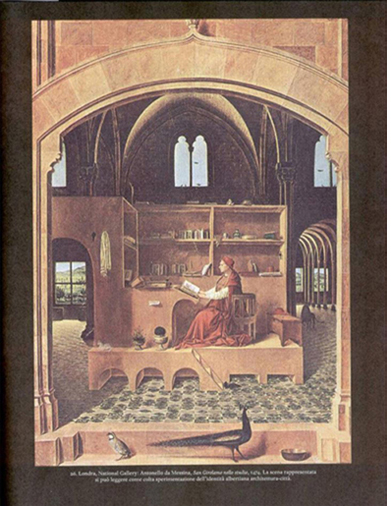
Antonello da Messina, San Girolamo nello studio, 1474

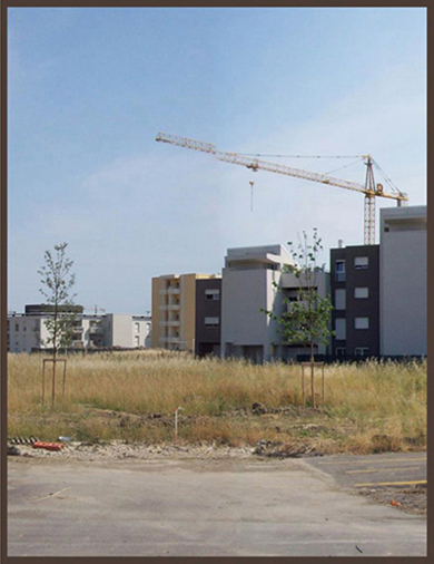
Our suburbs, Sant’Eurosia neighborhood, Parma, 2012
The thematic environment of the IP Erasmus Workshop 2013
After last year’s experience of designing for the historical nucleus of the city of Parma, namely, to transform the University Campus in the Oltretorrente district, the IP Erasmus Project entitled “Compact City Architecture: historical city centre design in Europe” means to extend its attention to take in those parts of the city dating to a more recent historical phase. As a result, we are looking at the parts we call the “suburbs”, generally characterized by factors of sprawl and the opening up of spaces to the extent of losing their architectural conformation, resulting in an urban identity that is ambiguous and no longer ascribable to either the morphological or social conditions nor the administrative framework of the compact city.
In the face of these and other critical situations, the suburban surroundings, in any event heavily populated and constituting the factor of greatest settlement weight in the body of the city, make themselves available for various densification strategies, above all to reiterate the premise before putting an end to the indiscriminate expansion of the settlement and subsequently verify the possibility of reassuming the conditions of morphological characterization and liveability typical of historical urban nuclei.
At this point it is permissible to ask ourselves: should we reconsider the suburban settlement in the key of the historic city, between density and formal articulation, or turn to other compact city models that have nonetheless been tried and realized in the experience of modernity? Or again, might there exist a third way to marry these often contrasting models according to a dialectic operation that also takes into account the contextual peculiarities of each city?
In the face of these uncertainties the project can anticipate different scenarios, that must nonetheless be capable of competing on the shared objective of re-conferring spatial and functional quality representative of the body of the city, which is by nature heavily composite but at the same time unitary. An operation, the latter, which veers in the direction of a “structural smart city”, where the quality of a presumed intelligent city is chiefly organized through the primary prerogative - that a city is a phenomenon of a spatial nature.
Within this problematic context, the project experimentation applied to the Sant’Eurosia neighbourhood in Parma introduces the theme of density conjoined to the idea of urban centrality, where by centrality is meant a point that is differentiated with respect to the repetitive continuity of the settlement fabric, where we can come upon the city’s main formal, functional, but above all representative components, chiefly of a collective nature. A central nuclearity that can structure and catalyze the fragmentary and heterogeneous diffusion of the suburban settlements, assuming its own strongly evident role, that of a bona fide “manifestation”, measuring itself against the theatricality of expression of an urban landscape seen as a setting.
The theatre of planning operations: a place of centrality for the south-eastern suburbs of Parma
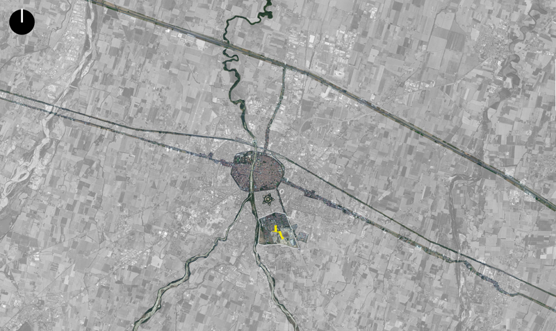
Wishing to assume by logical analogy the method of military analysis, this project requires a strategy of action that involves the field factor - in the sense of a theatre of operations - as an essential component to achieve the desired results. Departing from this assumption, the urban analysis carried out on the context tends to select some features that are useful to identify firstly the project area, the scope and physical space within which the project takes place, and secondly a comparison with the city that we wish to transform.
Here at a glance then we must immediately emphasize certain evolutionary conditions of the context at an urban scale.
First of all, the fact that the development of the suburbs to the south of the city has occurred through settlement of a predominantly residential character, in contrast to the part to the north of the Via Emilia, with its concentrations of major production, tertiary and transport logistics facilities, (via both rail and road).
The quadrant of the city that extended to the south-east beyond the former city walls from the end of the nineteenth century, between the Parma Torrent to the west and the Via Emilia to the north-east, features the densest residential fabric, in particular that which sprang up close to the historical monument of the Cittadella in line with high bourgeois villa models of the early twentieth century. This was to be followed by further stages starting from the post-war years up until the nineteen-seventies where there was an increase in speculative building of small blocks of flats and grand condominiums, even if featuring construction of quality, until reaching the stage from the nineties to today in which the conventional character of the extensive suburban fabric, mainly blocks on isolated lots, in effect saturated all the agricultural land still remaining within the southern portion of the Tangenziale urban ring road.
A more recent expansion phase where this part of the settlement is distinguished from the suburbs that are more adherent to the historical centre through factors of a different nature including:
a) marked expansion of the spaces in relation to objects constructed;
b) distance between buildings that prevents a relationship with respect to a shared space;
c) fragmentation of public space and the want of a relationship with private space;
d) lack of form of the empty urban space and self-reference of architectural figures of buildings immersed in a space that is discontinuous and undifferentiated;
e) lack of landmarks and places of identification and orientation;
f) dispersion of urban functions of public significance (schools, public offices, health services, facilities for culture and sociality in general, sports facilities, buildings for worship, etc.);
g) substantial lack of a hierarchy of settlement structure even in the presence of a strong tenure system (confines, properties, limits, minimum distances etc.);
h) poor and unqualified mobility and accessibility schemes in the face of substantial infrastructure aimed predominantly at automotive means;
i) qualitative failure of the availability of green surfaces, devoid of architectural design and urban functionality;
j) total lack of urban squares which are only partially supplanted by the surrogate spaces of shopping malls;
k) general diseconomy of the resource space through low settlement density;
l) lack of identity role and sense of belonging characterizing the idea of a neighbourhood, in the sense of an urban part identifiable among the parts of the urban whole (according to the structuring dialectic of neighbourhood-city).
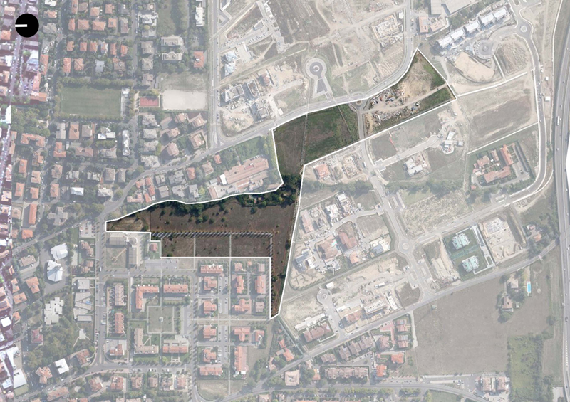
Within this framework of criticality which is not systematic but symptomatic of a settlement that often fails to become a city, the project’s theatre of operations can be identified in an articulated spatial context, but one oriented prevalently in a longitudinal north-south direction, featuring the following main features:
1) this is a large unbuilt surface intended for public green areas, parking lots, distribution streets, spaces for facilities and, if desired, elements of private building (everything still for the most part unrealized and designed to an approximate degree);
2) it proves to be a space that is barycentric to the urban fabric bordered by Via Montebello to the north, Via Traversetolo to the east, the Tangenziale ring road to the south, the Parma Torrent to the west.
3) the quantitative and functional consistency of the surrounding fabric constitutes a settlement and housing density of sufficient critical mass for a neighbourhood in the sense of an urban part capable of expressing an autonomous identity all its own;
4) the connective orientation of this empty space, while not morphologically configured, does herald potential for a pivotal and connecting role between the extant and future parts of the neighbourhood from north to south (from Via Montebello - Piazzale Maestri at the Eurosia shopping mall);
5) accessibility to the space is potentially high due to its location and the arrangement of the infrastructural network in course of realization.
Considering these conditions of potential structuring of the entire urban area described, the concept of space can be associated with that of place since this space, today substantially inert from the point of view of an urban role, could become a point of reference that would hierarchize, structure and especially bestow a reference identity upon the entire neighbourhood, thereby prefiguring it as a city within the city. In this process of developing it from abstract space to denoted and recognizable place, with the aid of public and private functions of collective interest, of figurativeness and representation through the city forms and the architecture that determine these, the project thus starts to deal with the theme of urban centrality in the sense that we still attribute to those parts of the city consisting of factors of uniqueness for sharing, relationships, and functional concentration as much as for a capacity to re-elaborate collective memory.
The place that creates centrality, with respect to surroundings that merely adopt it as a functional and symbolic reference, adds to the character and generically understood recognizability, also a sense of cultural, civil and coexistence value which, in this urban context, we can rediscover and participate in. The place of centrality thus represents all the environment it refers to and enters in relation with other centralities that are hierarchically ordered within the entire urban system.
In this search for urban meaning within a space yet unexpressed like that taken as the project theatre of operations, the component of the landscape imagery assumes a role of no secondary importance. The foundational aspects, through the logic of geometric matrix patterns due to archaic settlements, chiefly that of centuriation as part of the Emilian context, are accompanied by problems of imagery where the extant is denoted by poor formal characterization in both the sense of the skyline, and the ambiguity of the figurative rhythm that distinguishes the long fields of this suburban landscape which the spatial expansion has consented.
The urban sense of the scene, in other words theatricality as expression in a figurative sense through the architecture as well as a sense of drama through the inhabitants-actors, does not possess the characteristics to form the bedrock upon which to insert the project proposal. The urban scene is in this sense indefinite, frequently ambiguous, between banal icons and contradictions in its compositional layout.
The project must therefore assume the task not only of adding a component capable of re-conferring a role to this part of the city, but also of creating the surrounding conditions, as an urban interior, so that the new centrality can identify itself in this same urban context of acceptance. A design process that ultimately must involve and hold together, as a landscape, all the components, from that of the appearance of the individual architectural object to the image of an empty space that holds it together with the other components of the extant. Only in this complex relationship, between chorality and the individual protagonists of architecture, can the project find its theatricality.
The typological mechanism of/in the place of urban centrality
If we want to entrust, at least in part, the sense of a design action to the recognizable and communicable intermediary of the typological system, then unquestionably the theme of the densification and structuring of the city requires a typology of centrality characterized by being at the same time unitary and multiple, with an identity, but heterogeneous, introvert and extrovert, trans-scale and, in short, architectural and urban. A whole systematically arranged to the point of being deemed a typological device of geometric-spatial mechanics capable of satisfying complex operations, physiologies of use of an urbanism that is rich in services, relationships, sociality and, last but not least, representativeness.
The oft-used reference to the icon of "Saint Jerome in his Study" by Antonello da Messina, which visually performs Alberti’s Renaissance principle of reciprocity between building and city, clearly exemplifies the foundation of this mainly conceptual three-dimensionality of the architectural and urban device we have alluded to, in a visual continuity between public and private space, in line with a spatiality chained between the inside and outside, between the dimension of dwelling and urban living.
Within this dialectic, where, in seeking the project development of the urban centrality of the Sant’Eurosia neighbourhood, can be found two prevailing typological trends that have produced in the history of the Western city and the European one in particular, phenomena of densification and urban concentration under the banner of centrality.
On the one hand what prevails is the type of urban empty space, the Roman-style forum, as in the case of Parma, where functions are densified before the architectural structures that are intended to interpret a stable presence of the city as a place of exchange and directionality of services for the territory. An architectural archetype, the forum, which over the centuries was to strengthen its formal and figurative characteristics through the evolution of the piazza, over the long period of time of modernity between the Renaissance phase and the Twentieth Century. In this process, the architectonic elaboration of space seems to have seen the shape of the void prevail, as a space that is plastically defined through its layout and the conformation of its marginal scenarios, where unity or scenic articulation can play, arranged through the placement of the various soloist figures of the architecture. The spatiality of the shaped urban vacuum, whose depth of field is intended for the collective actions of the "civitas", remains a powerful catalyst for the concerted efforts of trade and relationships in general, thus becoming a place par excellence within the city, multiple or individual depending on its role in the dimensional and hierarchical structure of the city. The theme of the piazza as urban centrality is so rich and varied in its various historical interpretations that we must limit ourselves here to recalling its role with respect to the operation of the project workshop which finds in the City of Parma several exemplary cases of reference.
In other respects the typological search for an idea of centrality cannot avoid referring to those great unitary architectural organisms that range far beyond the role of a simple feature to become capacitors of activity, uses and meanings similar to the very idea of the city. As cities within cities, starting from a layout which is simple but a strong condensation of activities as in the case of the basilica, these buildings are considerable more complex and similar to paleogenetic matrices. From the layouts of Roman baths to fortifications and large abbey or monastery complexes, ending with the type of aristocratic palace and those "dominant themes" that characterize the large service buildings in the bourgeois industrial city such as hospitals, museums and schools, or in the revolutionary cities various constructivist experiments with social and political centres. In this scenario, the idea of “centrality” is materialized through the typological distribution tool inside an enclosure, plastically understood as a full volume of the city, according to the objective autonomy of architecture perceived first as building - and often as an icon - despite its articulation, vastness, and urban dimension.
In the dialectic between these two trends what is also more clear is the choice to entrust to the term place the task of interpreting, despite the recognizability of formal completeness, the mediation between the building and the fabric of the city, as well as between the full and the empty, surpassing the rhetoric of the epicentricity of the central nucleus as an expression of a "central power" (Arnheim, 1984).
Between these two prevailing ways to realize urban centrality, are forms of intermediary interpretation for contamination, complementarity, overlapping in virtue of the contextual aspects, the constraints of the structures, and the historic and geographical physiologies.
In addition, the contemporary condition, through sensitivity and urban lifestyles that have definitively changed in the space of a few decades, intervenes effectively in the design process to identify urban centrality, by invoking aspects that can be traced back as much to factors of global culture as of local culture, among memories and fresh new visions of the future, thus making us responsible for a more and more sophisticated role for urbanism and the architecture that interprets it, something which on the other hand has always distinguished simple settlements from the designing of a city.
The surviving albeit inadequate role of centrality is today played out in many suburbs with only a shopping mall, also in the case of the Sant'Eurosia neighbourhood whose name it shares, and not by chance. An absence of public squares and/or buildings of centrality which appears to be at the least singular if we think of the contributions in this sense in the recent history of Italian architecture, from the experiences of INA Casa neighbourhoods, to the studies and subsequent recovery of historical centres as the most up-to-date models of urbanism, and the many authors who have tackled buildings and urban areas strongly involved in the responsibility of creating centrality. For instance, through innovation of the civic, scholastic, museum and residential machinery with Aymonino and Canella, the formally concluded spatiality of Gregotti, the figurative allusion of Rossi, but also of Polesello, Semerani and Dardi, along with many other experiences of the Rome and Turin schools, which could also be mentioned if only to provide some references that are by now historicized, but not that distant, which gave rise to schools and research with a particular focus on the mandatory relationship between architecture and the city.
This issue has had less sophisticated theoretical outcomes but perhaps more important real achievements in modern post-war European architecture, in particular in Anglo-Saxon and Scandinavian environs, in the experiments with the New Town and in the reconstruction of many central and peripheral areas, and in urban redevelopment in relation to nodes of accessibility.
On the other hand, especially in Italy, paradoxically, the theme of centrality is highlighted only through a blatant lack of places of centrality since we have acted within an urbanization that has grown through self-referent additions of a predominantly real-estate character, without a minimum awareness of what has meaning and what the design of the urban structure can still mean for the operation of urban society, in a cultural but also economic sense.
The typological device that will be tried out in this opportunity of comparison between European schools, will therefore try to identify the design features that characterize an intervention of such a major foundational role for urban regeneration.
Layout, orientation, articulation - both horizontally and vertically through the game of levels - the relationship between the parts, the imagery and proportion of spaces, the relationship with the borders of the extant fabric, figurativeness as a variegated component that composes the overall image in terms of landscape and many other aspects, still constitute the steps of an interpretative proactive process aimed at a logical design characterization that is transmissible and contextualized.
Conversely, it is not easy to portend a typological device intended to interpret the centrality of the Sant'Eurosia neighbourhood precisely because of the lack of pre-existing elements strongly able, in some ways, to foster a clearer dialectic in an oppositional or conformative sense between project and context. To this indeterminacy - not to say banality - of the characteristics of the place is added the difficulty of a role of centrality focused primarily on the setting of a neighbourhood, of its functions first and foremost residential and hence devoid of a privileged relationship at a city scale, or even more so at a metropolitan territorial level. In any event, the role of a neighbourhood of centrality can take advantage of community issues, and of aggregation in general, as driving forces of the project with regard to social sharing, liveability and functionality, including representativeness and membership of the urban place. This is an aspect that proves decisive in general to be able to establish a community system that is open to external relations, in particular to other places of centrality that might arise in any neighbourhood of the city, analogously to that of Sant'Eurosia, thereby establishing a system capable of structuring the entire urban body, in particular that of the suburban sprawl.
Functional and quantitative elements
Knowledge of the theme and context can be enriched by using the research materials developed by teachers and students of workshops in the years 2011, 2012 and 2013 coordinated by the undersigned on the course for the Master of Science in Architecture at the University of Parma.
Further cognitive elements can then be acquired through site visits and direct contact made with the actual place and the city as a whole.
In any case, to allow a preliminary approach to the theme prior to the opening of the Workshop, you might want to set up a framework of functional and quantitative data articulated in terms of categories of use and quantity of areas relating to spaces for:
a) activities of social aggregation with a prevalently cultural character, clubs, associations, recreational, sporting and charitable organizations = 1,000m2.
b) exhibition activities = 300m2
c) events and poly-functional uses of a collective nature= 800m2
d) welfare services for health, employment, integration = 500m2
e) services for early childhood, school, permanent education = 1,000m2
f) start up incubators intangible/ICT products = 500m2
g) start up incubators tangible products = 500m2
h) craft activities of service to the neighbourhood (installers, maintainers, etc.) = 400m2
i) activities of service to the person (medical centre, gym, etc.) = 1,000m2
j) neighbourhood commercial exercises = 1,000m2
k) public facilities (bar, pub, pizzeria, restaurant, etc. ) = 1,000m2
l) offices = 1,500m2
m) sheltered residences for the elderly, self-sufficient = 3,500m2
n) rented accommodation with conventions for singles/couples/students = 3,000m2
o) residences of market value = 2,500m2
p) long-term/temporary residences = 1,800m2
q) hotel-type accommodation = 2.800m2
r) waste treatment and recycling units = 300m2
s) car and bike sharing centre = 200m2
t) … … … … … … … … … … … … … … … … … ….
To these surfaces could be added others, in particular for market activities, weekly or specialized (covered but open) for approximately 1,600m2 and, depending on the project solutions, in porticoed areas and covered routes.
In addition, the project will address the aspect of the outdoor urbanized areas, such as squares, courtyards and thoroughfares and green areas whose development is based on the quality of the design and the botanical features included as well as facilities for sports and leisure, but also for recreational activities of a contemplative or relational type.
*Michel Serres, Petite Pouchette, Editions le Pommier 2012, (trad. it. Non è un Mondo per Vecchi, Padua 2013, p.14).


