

Menu di navigazione

You are in: Home page > Magazine Archive > The Forms of City in Extension

Francesco Rispoli
The Forms of City in Extension
Two cases studies for the Campania district.

Progettual forms of the agricultural land: the Vallo di Diano.

The research aimed to develop, through the means of architectural design, tactics, and strategies for the development of the area of urban sprawl, identifying methods of reading relational, such as layering systems of geography, terrain, infrastructure, settlements, agricultural.
The research has dealt with two areas from very different geographies. In both cases the glance has privileged the idea of the form as a means rather than purpose. A plot that describes fields of possibilities, a regulatory discipline for a form to be not predetermined but open to constellations of meaning, governance to the architectural scale.
Constellations vs dis-asters: the slogan is that in both cases summarizes the meaning of design strategies that seek places where a sense may be possible, shared and transmitted and that make way for the possibility of the future.
The city in extension - what for Samonà (1976) "gives to all things of a territory open a particular value settlement in the discipline of its spaces, governed by the rules binding, even formally, every part of the campaign, modeling it on the behavior of agricultural processes and human presence and bringing back the whole idea of architectural city "- is the conceptual premise of the research. Which aimed to develop, through the tools of architectural design, tactics, and strategies for the development of the area of urban sprawl through a territorial condition which identifies methods of reading relational, such as layering method of geography, terrain and infrastructure, settlements, agricultural systems.
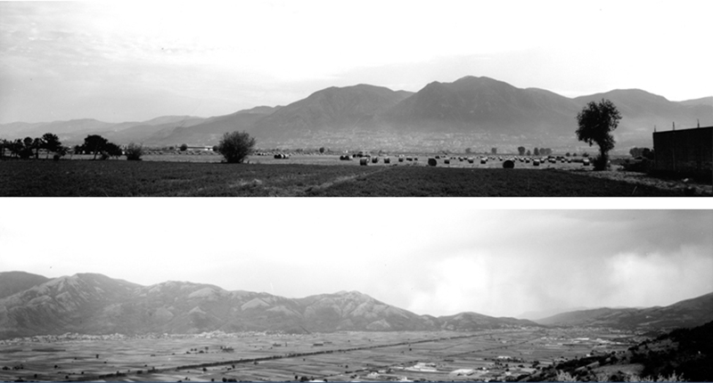
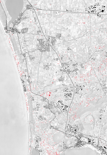
The research has dealt with two areas from very different geographies, one mountainous and interior, the other one flat and coastal. The first area, in the Salerno district, is identified by the crown of the smaller towns arranged in sequence of mountains on the edge of the Vallo di Diano. The second has the typical characteristics of the plain without its limitations orographic and stretches between Naples and Caserta district in a wide basin of the Volturno river.
The area of Vallo di Diano is crossed by the Tanagro river and is defined following the land reclamation of the Roman period, which is necessary because the original premise Pleistocene lake was then drawn by irrigation canals and by the cultivation of the soil. Over time it has developed in urban sprawl without connection to the existing smaller urban centers on the ridges nor with the linear city developed longitudinally along the highway. Here geography establishes strongly geometry, order and measures, and identifies the morphological specialization of the soil - the textures of cultivated fields and engravings of channels - the theme of his identity.
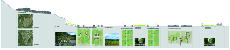
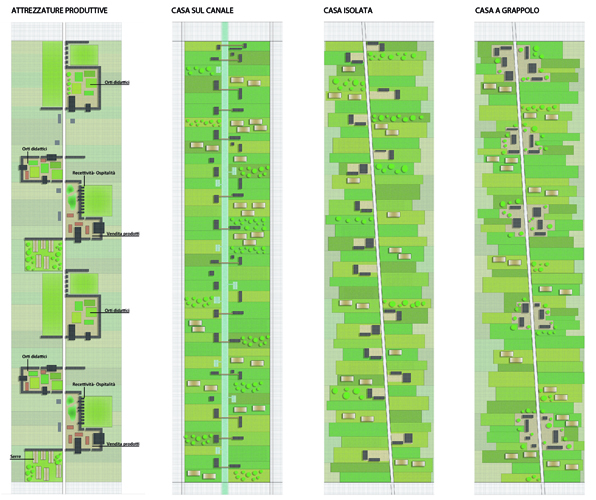
Elements of this field are: the ground, with the prevalence of agricultural use, the system of smaller urban centers, mostly emptied of meaning in favor of alternative employment soil downstream articulated along a network of streets interpoderali, structured exclusively on the relationship between home and work in the fields, the absence of relationships between these two systems, the dense network of longitudinal accessibility that runs alongside one of the two sides and affects the growth rules. For this territory has privileged the image of a big green city widespread in the agricultural landscape that finds meaning in this dimension and in its consolidation. The design of new courses that articulate the relationship between plot and occupation of agricultural soil can contribute to building shared visions by the inhabitants.
Starting from the idea of weak urbanization, are articulated regulatory devices, a filigree in the form of transverse filaments of variable density, connecting singular points of the two sides, along which are condensed built forms that guide the growth mode and the re- architecture definition and uses.
Through the system of piling agriculture, architecture elements (roofs, walls, platforms) thicken or thin out along the filaments in the receptive-productive patterns, agricultural or residential cluster aggregates or constructed in relation to the channels and spaces corresponding to that can evolve in time towards more complex forms. So you can build different rhythms and sequences in which the house - with its specific relationship with the cultivated soil - is the primary source from which it takes a composition on a large scale.
The city in extension to the north of Naples between the lakes country and Fusaro stands in an area of up to fifty years ago with a design of agricultural landscape with defined rules and measures, then subject to a significant road and rail infrastructure and progressive development of a housing dispersed indifferent to both the agricultural landscape to the road layouts.
The new residential uses do not show any sense of belonging: occupied, fenced and privatized lots, are autistic than the surrounding both the use and the form. The space between them is not public and all, but no man's land. A series of systems - agricultural, infrastructural and residential - living in a paratactic self-layering.
With this condition you compare the aspiration to a drawing in which the systems of elements, no longer fixed in predetermined relations uniquely, are able to establish, in the order of succession and in the presence of, a plurality of relationships. The compositional principle to restructure the urban landscape of farmland shall develop regulatory devices for the design of public space in the direction of mutual recognition of different collective memories and the multiplication of possible relationships.
Thus, cross-sections of the coastline and on major infrastructural axes are identified, marked by singular topography, and canals crossing axes, are the places where the character of the city can be reinterpreted and renovated using as materials of the same project elements of the landscape.
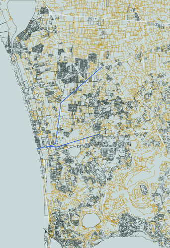
The peri-urban park in the south of the valley of the Quarto channel is structured like surfaces, lines and points that overlap on different layers and recovering directions mesh waiting for the existing design. At the center, the core of Varcaturo built in the "delta" between the Camaldoli channel and the Staffetta street. Relay, is passed through a sequence of thorns equipped which are configured as red threads that hold together the abandoned areas, unfinished buildings, equipment, agricultural areas with the aim to build sequences of public spaces capable of determining urban effects and leave traces on which interpolate the plot of projects to come.
In both cases, the sight has favoured the idea of territory other than that which he considers mere excipient technical infrastructure, and an idea of the form as a means rather than purpose. A sort of form forming, like Pareyson means. A cloth that describes fields of possibilities, a regulatory discipline for a form to be not predetermined but open to constellations of meaning, governance to the architectural scale.
The two case studies have different prerequisites as well as outcomes. In the north of Naples, the geographical features, infrastructure and settlements features show the utter indifference to each other. Here the project took the fragmentary condition as a set of bequests from put in sequence through new fragments, however, organised in a series of joints in the same body itself of the soil and of the settlements. Acupuncture in the nerve centers for determining urban effects, a sort of necklace create spaces where the primary elements in time reversing the consecutio theorized by the Italian school of urban analysis.
In Vallo di Diano the strength of geography is instead a resource must not be lost in the fragmentation. Therefore the project has insisted in the search for a watermark structuring future modification from basic shapes, patterns, formal settlements minutes, wide area networks capable of forming constellations and compatible figures with the spatial character of the area and the depth of the history of his landscape.
Constellations vs dis-asters: could be the slogan that in both cases summarizes the meaning of design strategies that seek places where a sense it may be possible, shared and transmitted and that make room for the possibility of the future.
Bibliography
Agnoletto, M., Guerzoni, M. (2012). La campagna necessaria. Unagenda dintervento dopo lesplosione urbana, Macerata: Quodlibet.
Branzi, A. (2006). Modernità debole e diffusa. Il mondo del progetto allinizio del XXI secolo. Milano: Skira.
Corboz, A. (2006). Il territorio come palinsesto (1983). In Viganò, P., a cura di, Ordine sparso. Saggi sullarte, il metodo, la città e il territorio. Milano: Franco Angeli.
De Rossi A., a cura di, (2010). Grande Scala, architettura, politica, forma. Barcellona/Trento: List Lab Laboratorio Internazionale Editoriale.
Donadieu, P. (2006). Campagne Urbane. Una nuova proposta di paesaggio della città. Roma: Donzelli.
Fregolent, L. (2005). Governare la dispersione. Milano: Franco Angeli.
Isola, A., (2002). Il paesaggio come metodo. In AA.VV. Infra-forme insediative e infrastrutture. Manuale. Venezia: Marsilio.
Neri, G., Petranzan M., Purini F. (2005). La città uguale. Scritti scelti sulla città e il progetto urbano dal 1966 al 2004. Padova: Il Poligrafo.
Secchi, B. (1989). Grandi spazi aperti. In Un progetto per lurbanistica, Einaudi.
Viganò, P. (2010). I territori dellUrbanistica. Il progetto come produttore di conoscenza. Roma: Officina Edizioni.
Francesco Rispoli is Full Professor of Architectural and Urban Composition at the Department of Architecture of the University of Naples "Federico II". He has been Scientific Director of several research programmes at the "L. Pisciotti" Interdepartmental Centre of Urban Design which he currently directs.


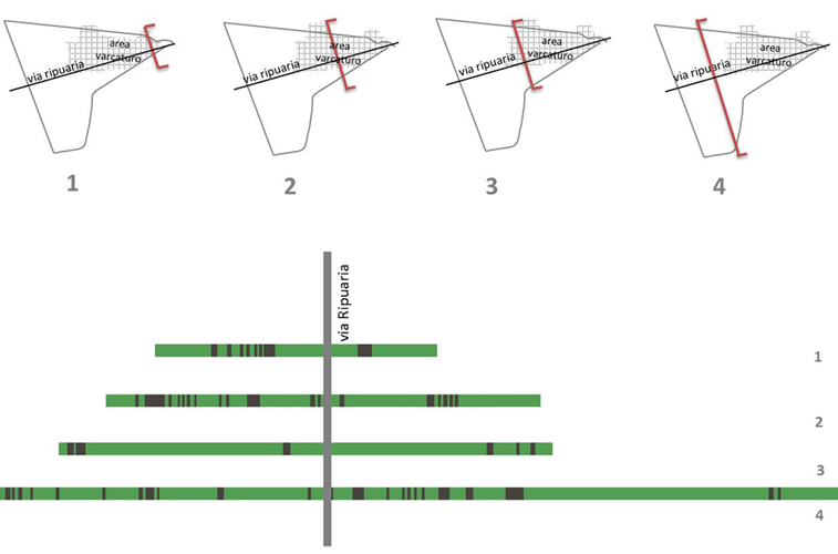
Restructuring devices of the agri-urban landscape. The delta of the Ripuaria street and the Quarto channel.


