

Menu di navigazione

You are in: Home page > Magazine Archive > Architecture of the settlement and infrastructures

Antonino Margagliotta
Architecture of the settlement and infrastructures
Sicilian landscapes between Palermo and Agrigento
.")
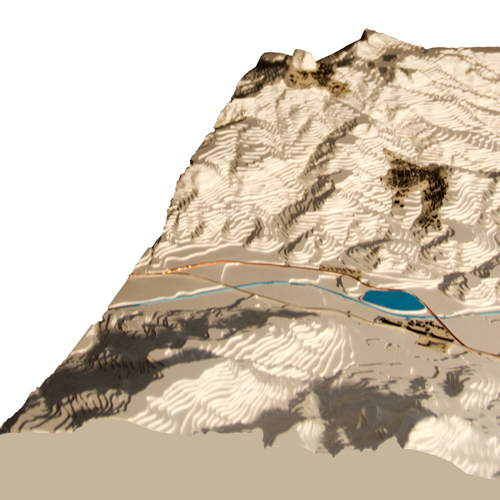
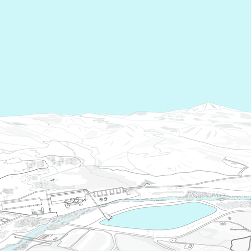
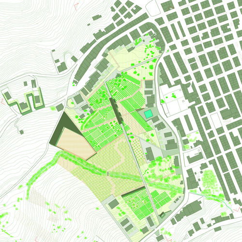
Road, landscape and city (Bolognetta).

Abstract
Today the full awareness of modernity imposes to question about the new morphological and dimensional nature of the places in order to understand the sense of the spatial relations and to try an aesthetic elaboration of them.
The theme has been developed in range of the Sicilian landscape and in particular in the system defined by an inner crossing of Sicily: the road that, joining Palermo and Agrigento, connects the Tyrrhenian sea to the African one and defines a land zone that is well-recognizable, where a multiplicity of conditions arises. In this way we have developed an interpretative and planning picture within an extended area marked by the presence of small urban centers which interfere with the network of infrastructures, by spaces of naturalist value, by the agricultural country and the rural settlements, by the industrial areas (the active and disused ones), by the hybrid places of the diffused city.
Therefore the architectural project takes charge of defining and indicating new strategies of development for this area, as well as supporting and verifying the theoretical thinking about the current state and the destiny of the places.
One of the most suggestive contents that are offered to the contemporary architectural research concerns the reappropriation of the places of the present which are marked by the partition of the urban form, by the influencing presence of the infrastructures and by an image of the country that is no longer an expression of the work of the land but, abandoned and transformed, it often expresses the characteristics of the dispersed city; these places require a renovated disciplinary approach in view of a re-evaluation of the rural environment, reason why it is important to think over the relation between architecture and context, that means to understand to what extend the architecture can expand the system of its relations in the area and what the measure of its intrinsic modification ability is.
Furthermore the full awareness of modernity imposes to question about the new morphological and dimensional nature of the places, in order to understand the sense of the spatial relations and to try an innovative aesthetic elaboration of them. Therefore, it concerns to apply (in an innovative and exciting way) all the categories of knowledge and interpretation that belong to the project, at reading scales of territorial type (or at least an intermediate one in respect to the conventional architectural scale), involving areas that are just apparently too extended; in other words to interact the big scale with the most specific scales of the architecture, in order to define new formal balances.
In particular we have developed an interpretative and planning picture of the Sicilian area, that is marked by smaller urban centers, by the network of infrastructures, by the agricultural country and the natural areas, by the hybrid places of the diffused city.
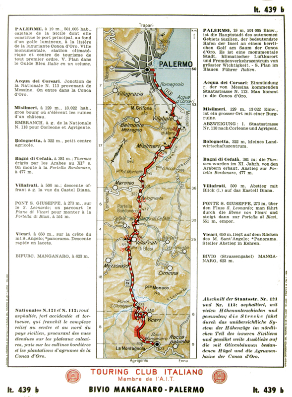
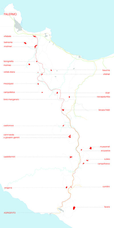
The system is defined by the road infrastructure that, connecting Palermo and Agrigento, represents an important inland crossing of the Island, it connects two seas (the Tyrrhenian sea and the Channel of Sicily) and marks a land zone that is well-recognizable from a geographical and historical point of view: a corridor between two polarities, two attractions, two directional stretches and continents where we can move towards (Europe and Africa).
The road (that together with the landscape connects what stands on the area) has an ancient layout that has remained almost unchanged over time: till the nineteenth century it is the same as the other roads of the Island, «vague traces rugged of holes and crammed of dust», that are described by Tomasi di Lampedusa in the Gattopardo; in the Bourbon age it is structured with works which are made in different sections between 1824 and 1855, it takes shape of driveway during the first half of the twentieth century with the rank of national road; the variations of the layout (in order to evade the crossing of the residential areas) and the transformation in expressway date back to the 70s; the current phase of modernizing has offered the possibility to interact the research with the Regional Administration and the ANAS.
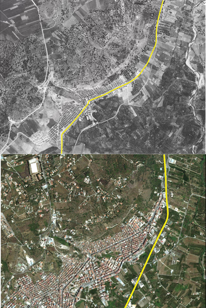
The presence of the road is essential for the dynamics of transformation of the country and of the settled cities along the way; between road and city subsists a relation that, almost like an ancient myth, is a courtship: up to a certain age the road chases urban centers, clambering up the mountains, crossing them, directing their growth; at a later time, when the road moves to the valley floor, the cities have to run after it, moving new activities and services close to it.
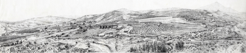
The landscape defined along the way does not appear with the archaic characteristics of the balance between artifice and nature nor is univocally classifiable in the ways in which it was crystallized in the static and conventional image of Sicily: in the hilly areas of extremity, it appears neither marked by the rich vegetation of the citrus groves of the Conca doro near Palermo nor by the dry lands of the sulfur basin near Agrigento; the inland is not even the extensive latifundium of pastoral and cereal-growing vocation that Goethe describes during his journey in 1787 («it does not consist of a single great plain, but of the sides of mountains and hills, all planted with wheat or barley, which present to the eye an unbroken mass of vegetation. Every spot of earth suited to this crops is so put to use and so jealously looked after, that not a tree is anywhere to be seen; indeed the little villages and farm-houses all lie on the ridges of the hill, where a row of limestone rocks renders the ground useless»); nor the sunny and desolate landscape narrated in the Gattopardo («an endless undulant aridity of rumps over rumps
.never a tree, never a drop of water: sun and dust»); it is not also the enchanted landscape that Salvatore Quasimodo transfigures in the valley of Platani, in the knot of Acquaviva wherein the road, the railway and the river intersect themselves, where the poet lived a «homeric childhood».
The agricultural crisis and the abandonment of the country, the dispersion of the city and the assumption of the characteristics of the suburbs by the extra-urban areas, the excessive anthropization and the settlement of activities and incoherent languages have made this landscape complex and fragmented, often becoming the place of disintegration and loss of form. In this scenery we find the interest for different phenomena that the research has highlighted:
The urban centers that are considered smaller, both in terms of the hierarchical strategies related to the use and consumption of the area , and for the reduced attractive abilities related to the economic conditions, to the progressive decrease of the population, to the weakening of the internal and external spatial relations;
The existing infrastructures that are important organisms, able to engage and give vitality to an extended territorial context and represent independent signs that extend themselves in landscapes which potentially have a prevalent agricultural and/or naturalist connotation.
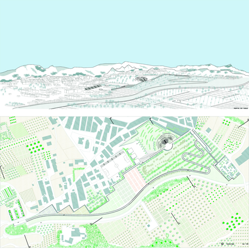
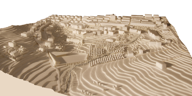
Through the architectural project, we have tried to elaborate a new urban paradigm that, through a reflection of the country, can give a sense to the smaller settlements, that are increasingly on the verge of losing their organizational capacity in the area; in turn, the elements of the infrastructural system, which are seen as catalysts of the area, have the possibility of defining instrument of contextual intersection and new devices of composition to elaborate.
Indeed, the new planning intends to take position against the self-referential management (which are induced by the current economic situation) in order to start, beginning from architecture, new policies for the city and the area. The project, seen as a tool for understanding and interpreting the physical environment, offers a strategic vision that imagines and organizes a hypothesis of development, explaining cultural, economic, environmental vocations of the area itself; in this sense the transformations do not originate from economic and social matters anymore, but from a new logic which starts from the interpretation and reconstruction of the landscapes; along these lines, the projects become the opportunities to define fragments of city, to give a sense to the new widespread urbanity, to relate the present infrastructures and the new ones, to organize garrisons that can give not only the awareness of the rural presence but also collective services for the social support of the area (cultural and free time places, alternative tourist areas).
The geographical dimension of the research field makes possible the exploration and the description of a multiplicity of spatial situations that allow to record the environmental and urban geography of Sicily: indeed along 120 kilometer we can find different urban densities and intensity of urbanization; about 30 residential areas (which are different in history, living traditions and dimension) are connected together and to the more extended area. And if Sicily is a metaphor of the world (as suggested by Leonardo Sciascia who was born in these places), the urban centers, with their countries, are a credible and fascinating sampling of the world cities, able to reveal problems that must be faced, whose results can be then used to define processes that will be generalized.
The research has explored, in an incisive way, concrete cases which have been identified through the whole extension of the system (through the educational activity that this year we have conducted at the schools of Architecture and Engineering):we have defined a general vision where the projects have begun, starting from the relations between country and infrastructures, from the connection between the cities and their boundaries, testing solutions for an innovative spatial reorganization. Collaterally, for some emblematic knots, we have involved professors of Italian and foreign Universities, in order to compare different sensitivity, approach, methodology: thanks to the project there is now the will to clarify the requirements of completion of the urban realities that interfere with the infrastructure, trying to connect all the elements , to arise the identity matters, to confer, above all, value to the country, favorite point of view for any possible transformation of the landscape.
Bibliography
Augé, M. (2007). Tra i confini, Città, luoghi, integrazioni, Bruno Mondadori Editore, Milano.
Goethe, J. W. (1816). Viaggio in Italia, ed. it. Arnoldo Mondadori Editore, Milano (1983).
Tomasi di Lampedusa, G. (1958). Il Gattopardo, Feltrinelli, Milano.
Margagliotta, A., Tuzzolino, G.F. (2007). Spazi di città. Spazi di natura, Edizioni Abadir, Palermo.
Provenzano, I. (1998). Città e campagna in Sicilia: le trasformazioni del paesaggio, Pubblisicula, Palermo.
Antonino Margagliotta is an associate professor of Architectural and Urban Composition. He teaches in the degree course of Ingegneria edile - Architettura of Palermo and in the degree course of Architettura of Agrigento. He has taken part in funded research works (PRIN, of Athenaeum, regional ones) acting as supervisor and coordinating working groups.


